This week we welcome back Wren Rowan to complete their article on the Kingdom of Elmet. Read part one before beginning this article.
So what do we know of the people of Elmet? And how do we know it?
After over 3 centuries of Roman rule, most of the people in Britain could be fairly described as Romano-British – you can’t be colonised for that long without taking on some cultural aspects.
They would have spoken Brittonic, a language that developed into modern Welsh, Cornish and Breton. It also developed into Cumbric, spoken in Cumbria and parts of southern Scotland, and possibly as far south as the Dales, but this language went extinct in the 12th Century.
As put by Thomas Williams in Lost Realms, Bede “offers no sense whatsoever of Elmetian identity, and only very little of Elmet’s geography”.
In his Ecclesiastical history, the section called “Edwin and his people accept the faith, and are baptized by Paulinus”, we learn that there is a church built for King Edwin after his conversion, and that this stood at Campodunum – likely to be the Camboduno mentioned in a 3rd century Roman document. He tells us this church was shortly after burnt down when the pagan king Penda and his armies came northwards. The church is then rebuilt in the region of Leeds, and the stone altar, which survived the fire, is moved to a monastery in Elmet wood.
What Bede doesn’t explain, possibly because he doesn’t know (he was after all writing many years after the fact), is where any of these places are. In recent years, historians have narrowed down the location of Campodunum to between Manchester and Tadcaster, which is still a vast area to be working with. He doesn’t tell us where Loidis is, nor where Elmet is, and he doesn’t tell us where those places are in relation to each other.
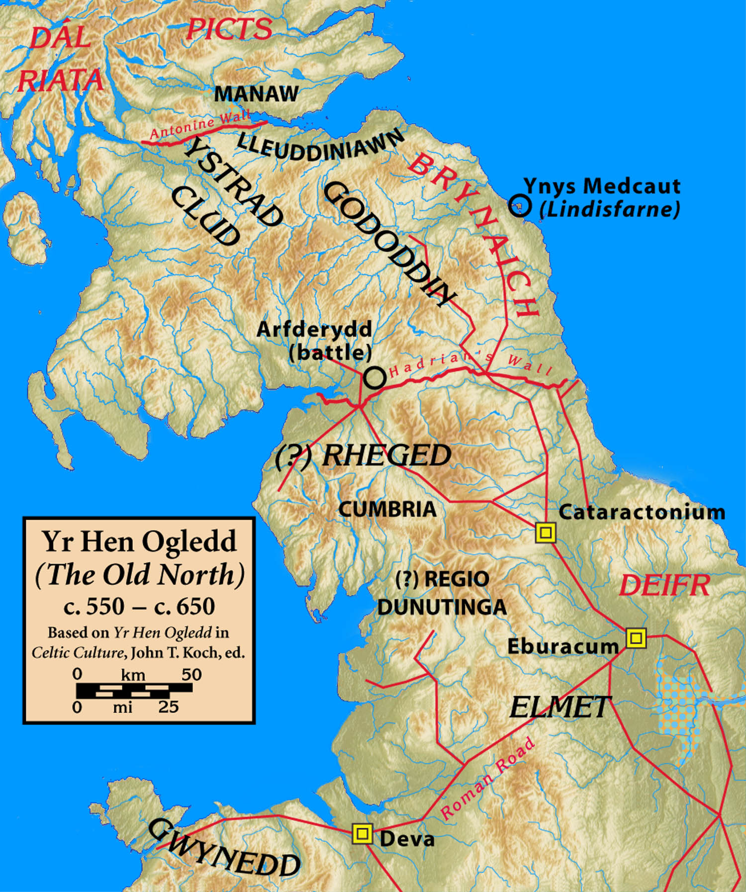
Yr Hen Ogledd (The Old North) c. 550 – c. 650. Showing placements of peoples and sites based on Celtic Culture: A Historical Encyclopedia, John T. Koch, ed. (2005), ISBN 9781851094400, except that positioning of Roman roads is based on the Iter Britanniarum of the Antonine Itineraries and other sources, supplemented by Koch’s additions. Image: Creative Commons Wikipedia
What’s in a name?
In the absence of historical documents giving us useful information on the subject, we must turn to other sources to establish where Elmet was. One of these sources is place names – something numerous historians have used over the years to make sense of this period.
To the east of Leeds, in a wide corridor around what was Ermine Street, aka the Great North Road, lie several settlements that offer helpful insight into where the eastern boundary of Elmet was. Sherburn-in-Elmet and Barwick-in-Elmet are the two most obvious examples, since their names still include the -in-Elmet suffix. However, if you look at historical maps and other documents, there are places that once included that suffix whose names have changed. These are: Clifford (Clyfford in Elmette), Micklefield (Mickelfeld in Elmet), Saxton (Saxtun in Elmet), Kirkby Wharfe (Kyrkby in Elmete), Burton Salmon (Burton in Elmet) and Sutton (Sutton in Elmett). Linguistically, these names are all Old English in origin – no doubt if these places existed when Elmet was still a Brittonic kingdom they would have had Brittonic names. However, post annexation by Northumbria, new settlements will have grown, old settlements been renamed. But if Elmet still existed as an administrative entity, and you wanted to specify where a village was (maybe one that had a similar name to another closer to home) how, as an English person from neighbouring Deira, do you identify one from the other? One way perhaps, is to specify that one of them is in Elmet.
There are other, less obvious, ways to find where Brittonic populations continued to live after the Anglo Saxons came over and started pushing their way westwards. This involves exploring the etymology of place names that don’t have helpfully obvious suffixes.
We can look for names that are Brittonic in origin. Due to the Brittonic peoples being gradually pushed to the western edges of the island, however, a lot of that linguistic heritage can only be found in Wales. The word Cymru, which is the Welsh word for Wales, means ‘land of fellow-countrymen’. Cumbria, as a place name, is very similar, and it’s no coincidence. Until the 12th Century, the people who lived there spoke Cumbric, a descendant of Brittonic that unfortunately didn’t survive. There are still some Brittonic names hanging round on this side of the Pennines though. One notable example is Pen-y-ghent (one of the Three Peaks) where “pen” derives from the Cumbric word meaning ‘top’, y means ‘the’ and Ghent is more obscure but could mean ‘border’ (making it the hill on the border) or ‘heathen’, perhaps in reference to nearby Scandinavian pagans (making it a hill of heathens or a hill near heathens perhaps).
The name Leeds derives from Loidis, with likely Brittonic origins. Nearby Ledsham and Ledston also come from the same root word. It is unclear exactly what the meaning of this name was, but a strong theory is that it meant ‘people of the fast flowing river’ (the River Aire)
To establish more firmly where native Brittonic populations remained during the period of Anglo-Saxon expansion and settlement, we can look to the Old English place names, ones that these new settlers gave to the people who were there before them. Because, while Cymru is a name given by the native inhabitants of Britain to their homeland, the name Wales derives from the Old English word ‘wealh’, which means foreigner, and was applied to pretty much anyone Brittonic. And it’s not only Wales that can trace its name back to this word – Walsden (near Todmorden) means valley of foreigners, Walshaw (near Hebden Bridge) means copse of foreigners, and Walton (in Wakefield) means town of foreigners. All these names indicate that there were populations of Britons in these places while the Anglo-Saxons settled around them. They are also all within the footprint of Elmet.
The name Elmet itself is also worth considering. It seems to be derived from Latin, and likely means Elm forest. Thanks to Dutch Elm disease, there are very few elms left in this country. And while there are plenty of trees in West Yorkshire, we can hardly claim that it is forested these days. However, there are plenty of place names in and around Leeds that indicate that it once was. The suffix -ley, as in Burley, Headingley, Bramley, comes from the old English word “Leah” meaning a clearing in a forest. And it is quite hard to have a clearing in a forest without a forest in the first place. Many of these places are recorded in the 1086 Domesday survey. And although this collation of information for King William is separate from the fall of King Ceredig of Elmet by about 400 years, it can still provide us with proof of people living in wooded areas.
After Elmet
Things didn’t exactly calm down in Britain in the period following the absorption of Elmet into Northumbria. In fact we can be fairly certain things stayed pretty messy
Following Edwin’s takeover of Elmet, he also brought a number of other kingdoms, both Brittonic and Anglo-Saxon, under his rule. This includes the Kingdom of Gwynedd in northern Wales. Edwin was clearly quite ambitious.
The King of Gwynedd, a man named Cadwallon, fled to Ireland. Some time later, he returned and allied himself with the kingdoms of Powys and Mercia, led by the last pagan king of Mercia, a man called Penda, against Northumbria. They met the Northumbrians in battle in 633 at a place that’s either called Heathfield or Hatfield Chase. Edwin was killed during this battle.
A year or so later, Cadwallon was killed by Oswald of Bernicia (son of Aethelfrith), at the battle of Heavenfield, near Hexham.
Oswald reigned in Northumbria for 8 years, until Penda and his armies killed him at the Battle of Maserfield (potentially near Oswestry)
The next 13 years were dominated by Mercia, a kingdom with a powerful base in the midlands. But in 655, Oswald’s brother Oswiu killed Penda at the Battle of the Winwaed – we know the Winwæd was a river of some sort, but the exact location is unclear. Most historians seem to agree it was in West Yorkshire somewhere, with one strong theory being that it refers to Cock Beck at Aberford .
Bede was keen to point out in his telling of the story that following the death of Penda, his son Peada succeeds him, and Peada is Christian, and thus the last of the Pagan kingdoms becomes Christian.
This is not the end for Elmet. The kingdom itself may have disappeared into the murk of the past, but people still lived there, with their own distinct identity and heritage. Absorption into a larger kingdom did not mean they lost who they were. As late as 1315, a Florentine bill of sale for wool, mentions Elmet, as well as Loidis (Leeds), Tresche (Thirsk), and Vervicche (York). Still later, Elmet is used as a name for administrative areas, such as in the parliamentary constituency of Elmet and Rothwell.
Sources:
West Yorkshire and the Ancient Kingdom of Elmete – Martyn T Clarke (YP 942.81 CLA)
Grim’s Ditch – West Yorkshire Archaeology Advisory Service – Dave Weldrake 2011
Trioedd ynys Prydein: The Welsh Triads (891.66 TRI)
Poems from the Book of Taliesin – J. Gwenogvryn Evans (891.66 TAL)
Bede: Ecclesiastical History of the English People (Book 5, Chapter 23: The Life and Death of Abbess Hilda) (274 BED)
Lost Realms – Thomas Williams (941.01)
British Christianity in the Kingdom of Elmet – Ian Thompson (YP 274.2 THO)
In Search of Elmet – R. Geraint Gruffydd (YQP 942.81 GRU)
Your City’s Place Names, Leeds – Harry Parkin (EL 910.014 PAR)


A very interesting post. Across almost the whole of modern day West Yorkshire (with a rough correspondence to the putative Elmet), even places that appear totally Anglo-Saxon may have deeper Brittonic origins. For example Birstall may derive from the Welsh words bryn and lle meaning ‘hill’ and ‘place’ respectively.