Librarian Antony Ramm takes a brief look at a very useful map of Leeds city centre in the 1960s…
We recently welcomed University student Jessica Heath to the Central Library, to lead an exploration of the 1970 Leeds Clothing Strike. As part of that workshop, various books and other resources from our Local and Family History department (LFH) were made available for attendees to take a look at. Broadly relevant to the subject at hand, the material covered aspects of the post-war textile industry in Leeds and West Yorkshire, trade union activity in the region, newscuttings following the strike action itself, and much more. What was most directly of interest to students of the 1970 event made its way into a permanent resource folder, which is now available in LFH by asking staff at our counter on the 2nd floor. A recent article provides more information on the folder’s contents.
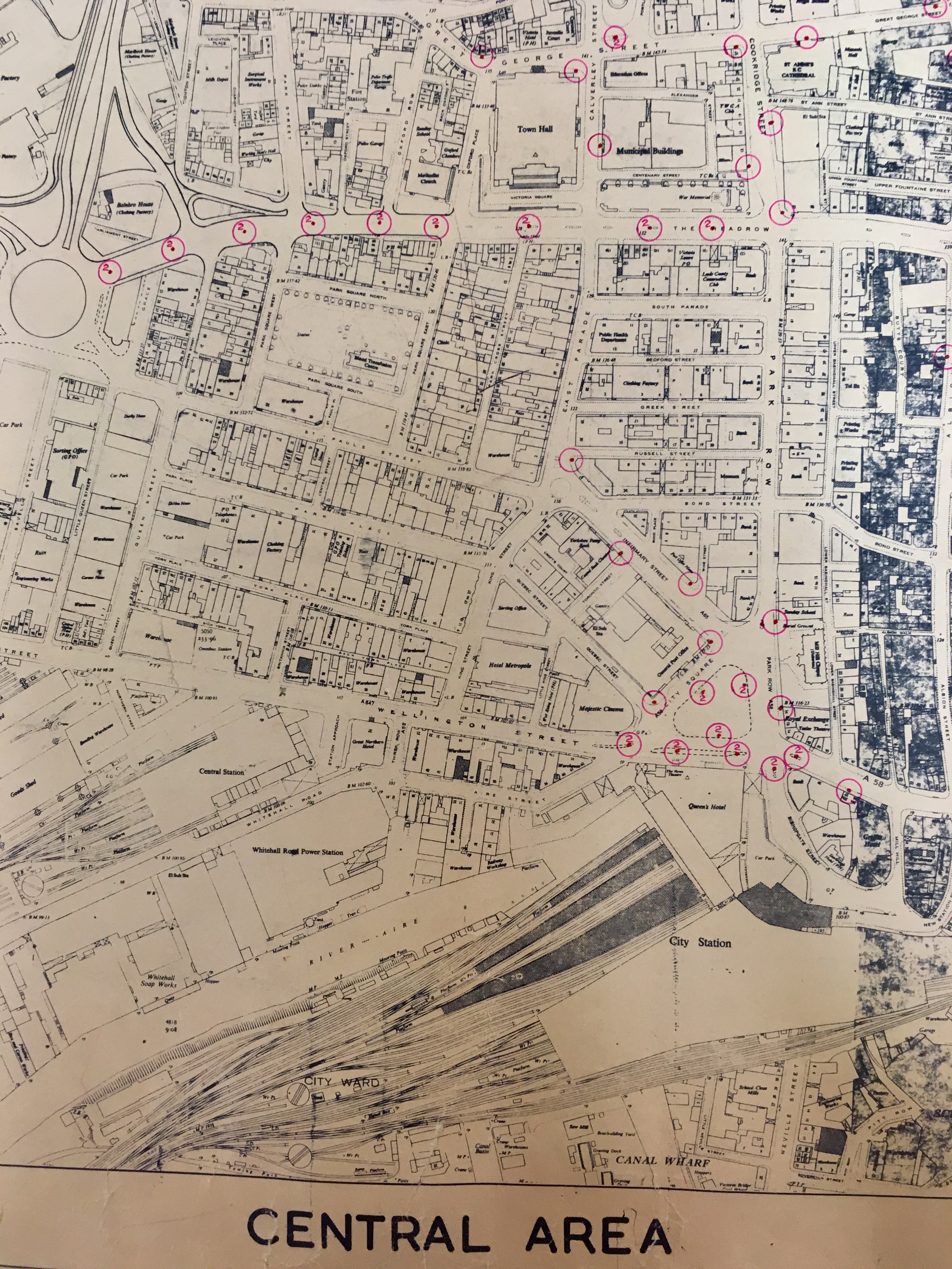
What did not make it into that folder, but which attracted plenty of attention at Jessica’s workshop (and then again at another workshop looking at the history and legacy of the textile industry, led by Emily Owen, once more at the Central Library) was a map of Leeds city centre from 1967. The map’s identifying label indicates that it was created by the City Council’s Highway Department – but with no suggestion as to what purpose it was made. But that does not really matter, at least not for our workshop, or this blog. Because what is of interest is the level of detail seen on the map, and the extent of the area it covers.
The scale appears to be similar to that seen in the Ordnance Survey 1:2500 series (roughly, 50″ to 1 mile), giving enough detail that the purpose of individual buildings is noted on the map; but – crucially – this is one complete map, revealing all the city centre at a glance (unlike the aforementioned OS series, from which any researcher wishing to see the entire city centre would have to request a number of smaller maps to make the whole.)
Anybody interested in viewing the map should make a request in the Local and Family History department, by quoting the shelfmark ML1967. And those intrigued by the wider context for this map and Leeds city centre in the mid-to-late 1960s, is well-advised to take a look at our Leodis photograph archive of images from 1967 itself: a curious compendium, including a passport photograph of Alan Ackybourn, visits to Leeds by various national and international figures, a fire at the junction of Call Lane and Briggate, plus a snapshot of an accident involving a stolen car – any one of which would make an ideal subject for a future blog article…

*Two readers of this article have since offered a reason for the numbering on the map: Michael Lycett in a comment below the article on October 9 2021, and another reader who emailed in with the following information:
If you look around the sites where the red circles are using images on Leodis, you will find that there is a distinctive design of street light in those images.
They will have either one or two light heads and in some cases I wonder if that is not the reason for the image was taken. (See the two examples below)
So where the red circle has a red dot the street light will only have one lamp head (See this image on Leodis) and where it has a 2 it will have two lamp heads (See this image on Leodis).
I started checking around City Square and worked up to The Headrow and Park Lane and it became clear there is a correlation between the map and the street lights.
Since there are not many dates for the images it could be part of the original plan where to site them or an amendment plan as Leeds roadways change as it grew.
Note that on the plan Westgate roundabout is not completed.
Paul T Burniston via email, April 15 2022

Do the red circles denote street lamps? The number two denoting a double lamp?
Hi Michael,
That’s a very good suggestion! We have to admit we’re not 100% sure – but we’d love to hear from any readers who do the meaning of the red circles.
Thanks,
Antony
Librarian
Leeds Central Library