As part of a series examining family history resources for beginners, Librarian Antony Ramm explores the local map collection at Leeds Central Library and online, briefly showing how they can be used to support genealogical research…
As well as being seriously fascinating in their own right, maps are one of the most important of what we might call the ‘second rank’ of resources for the family historian. Not, that is, where you would start your investigation into the names, relationships and life-dates of your ancestors, but part of the next step: uncovering more about the lived experience of those in your family tree – principally, where they made their home, and the nature of those residential areas.
Most public libraries and archives will have strong local map collections, which will usually include a core of Ordnance Survey (OS) maps – these have been produced at regular intervals since 1850 and are by-far the most detailed maps easily available to researchers. Alongside the OS maps will normally be found a looser collection of maps produced for one-off, bespoke purposes – these are usually less-detailed than the OS maps or, if equally detailed, of such limited range geographically as to be restricted to very specific purposes (examples here would include 19th-century maps detailing proposals for urban improvements – such maps provide lots of information and detail as to building usage, but usually only for the streets of direct relevance to the map’s purpose).
Leeds Central Library is no different – you can read more about the make-up of our map collection in a related research guide. Below, you will find a brief breakdown of our different map sequences, and some suggestions for getting the most from them for family history research. If your family history research takes you away from the Leeds area, you will likely find that other libraries or archives have equivalent collections to those listed here.
*****
1:1250 (50” to 1 mile): 1950s to date
These are our most detailed modern maps, and particularly notable for featuring building and house numbers – a feature not otherwise seen in our map collection outside of the mid-1800s. The sequence covers the Leeds Metropolitan district only, though we do also hold slightly less-detailed maps in the 25″ to 1 mile scale for the areas outside the main urban settlements, from the 1960s to today.
Family Historians should use these maps with: birth, marriage and death certificates, parish registers, municipal cemetery records, and phone directories – all these records will give addresses of ancestors, which can be traced using the street names and building numbers on these maps
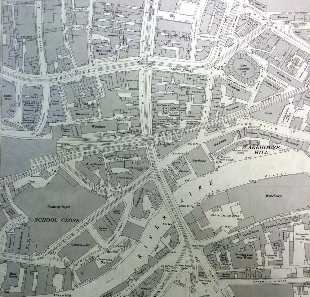
1:2500 (25” to 1 mile): 1893 -1938
This sequence is one of our most-used map collections, covering a 40-year period of huge social change, much of which can be literally mapped through, variously, the emergence and disappearance of so-called ‘slum’ back-to-back housing, industrial zones, transport facilities, entertainment services and other amenities. The 25-inch scale gives a very good range of detail, allowing the viewer to identify individual buildings in a street, albeit without the aid of house numbers as seen in the 50″ scale described above. The Central Library sequence cover most of West Yorkshire, with some gaps and patchy coverage for the rest of Yorkshire. This sequence continues for the less built-up areas of the Leeds Metropolitan District, from the 1960s to the present day.
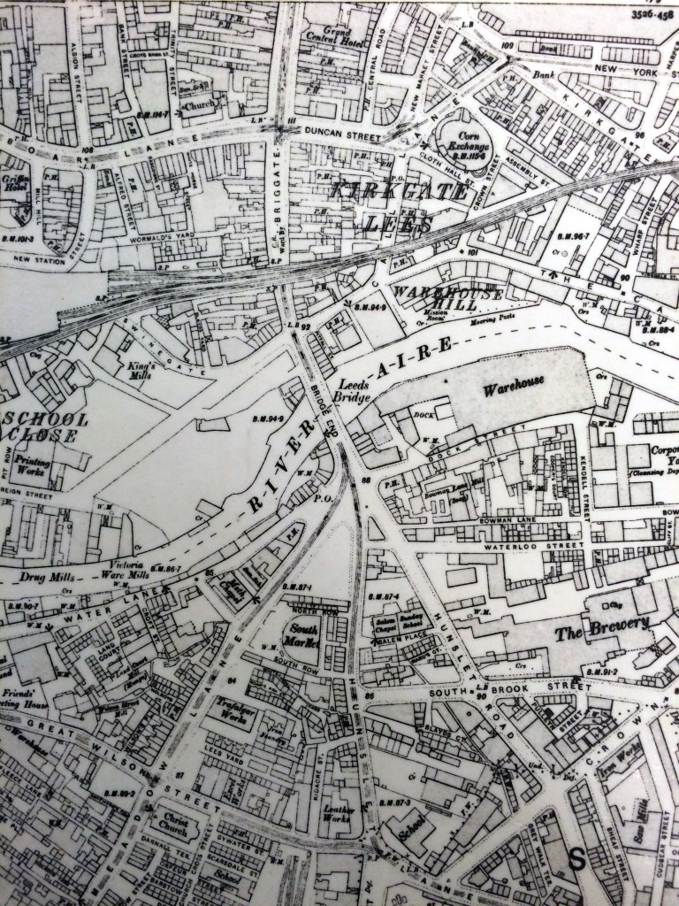
Family Historians should use these maps with: birth, marriage and death certificates, parish registers, municipal cemetery records – all these records will give addresses of ancestors, which can be traced using the street names on these maps. Trade directories are particularly helpful here, as their street-by-street gazetteer can be used to match specific house numbers to map locations (trade directories give helpful contextual information, such as indicating when one street intersects with an adjoining street)
Find these maps online: www.maps.nls.uk
1:10000 (6″ to 1 mile): 1850 and 1890 – present day
The very earliest Ordnance Survey maps sequence, which continues to the present day. The most useful edition for family historians, however, is the first in this series – the 1850 6″ to 1 mile maps, which are, broadly-speaking, the only comprehensive maps covering all of Leeds until the arrival of the 25″ to 1 mile series in the 1890s. While Leeds Central Library does also hold some very-detailed 5ft to 1 mile maps for Leeds, these only cover the immediate centre of the old Township; although much residential property can be found in that map series, many family historians will find that their ancestors lived outside those boundaries . So, while the 6″ to 1 mile OS series does not offer anything like the detail of those 5ft to 1 mile maps (nor, indeed, the 25″ to 1 mile), it does at least have the immense virtue of covering the entirety of Yorkshire. Names of main streets are visible on the 6″ maps, as well as the location of major buildings and sites such as Town Halls, Churches, Schools, etc.
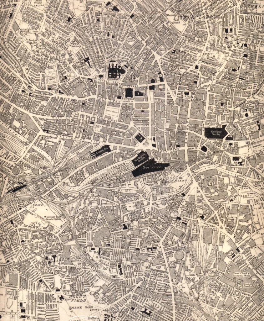
Family Historians should use these maps with: birth, marriage and death certificates and parish registers – all these records will give addresses of ancestors, which can be traced using the street names on these maps. Trade directories are particularly helpful here, as their street-by-street gazetteer can be used to match specific house numbers to map locations, as well as helping to identify the names of the unidentified, smaller streets and yards that run off the main, named streets (trade directories give helpful contextual information, such as when one street intersects with an adjoining street)
Find these maps online: www.maps.nls.uk
Non-OS maps: 1726 – 1850 and 1850-1890
This sequence actually continues beyond 1890, but is particularly useful for the period to the advent of OS maps in 1850, and the forty-years between the 6″ to 1 mile maps arriving in 1850 and the 25″ to 1 mile maps arriving in 1890. This is a broad category, which includes maps of the whole area of Leeds (in varying degrees of detail), Estate maps, maps of urban improvements and utilities, maps of very specific purpose (e.g. locations of public libraries), and much, much more (our research guide lists further examples, but contact us for a fully-comprehensive list). While many of these maps will not aid many family historians, owing to their very-limited detail or niche coverage, some genealogists will find surprising usage on closer inspection – an 1844 map of Briggate held at the Central Library, for instance, provides one of the few examples of house/building numbers being present on a pre-OS map series. Those maps showing the entirety of the town centre, and surrounding areas, can – even with limited detail – help family historians to roughly pinpoint likely locations for the houses of ancestors or, at the very least, gain a broader awareness of life in a particular time period.
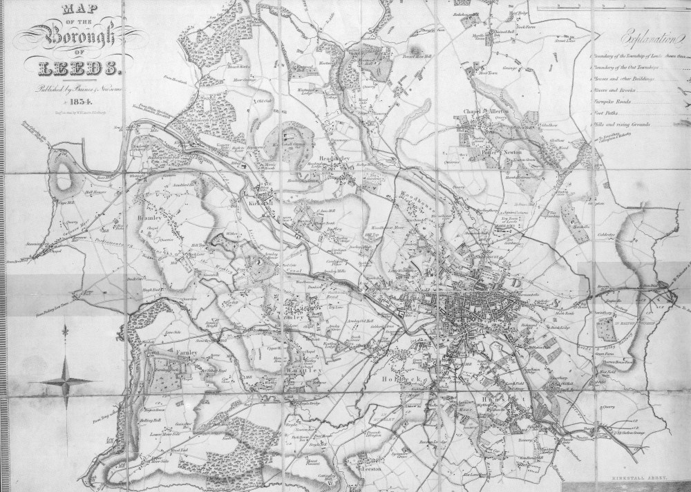
Family Historians should use these maps with: trade directories (available from the late 18th-century) can be used alongside whatever street names or other identifiers are found on the map in question; historical accounts of life in Leeds (or other relevant areas) at the time of the map being compiled; parish registers (though there is likely to be limited records of addresses in these registers until the early 19th-century); birth, marriage and death certificates (after 1837); any pre-Census lists of people that are available (including Visitation records)
Find these maps online: low-res versions may be found with some searching but, for best results, please contact us – we may be able to arrange for a high-res copy to be sent to you (fees will apply – and note that this service is not available while the Central Library remains closed)
You can find other maps online at the David Rumsey Map Collection website, including maps of Leeds and Yorkshire.
Further reading
- Dr. Sophie Kay – ‘Mapping Magic for the Family Historian’: https://alangodfreymaps.co.uk/SophieKay.pdf
- Ibid. – ‘Walking in their Footsteps: Maps and the Family Historian’: https://parchmentrustler.com/family-history/footsteps-maps/
- Sarah Lee – ‘The Use of Maps for Family Historians’: https://alangodfreymaps.co.uk/SarahLee.htm
*****
For further information, use our research guide or contact the Local and Family History department on 0113 37 86982 or via localandfamilyhistory@leeds.gov.uk

One Comment Add yours